Saarland Map: Hubert Families who migr. to Perjamosch /Banat, Austria-Hungary
Last Update: 15 April 2012
![]()
![]()
![]()

History of Saarland In More Detail
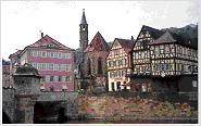
The Saar River is 150 miles long and begins in the Vosges Mts. in Eastern France and flows generally N. to join the Moselle SW of Trier, Germany. It forms part of the border between France and Saarland, a German State. The capital of the area known as Saarland is Saarbruecken. The population was German speaking and their religion was usually Catholic. The area holds little historical data unless one digs deeply into the history of conflicts between the German and the French rulers.
1000 - About this time the Iron Age began....
800 to 400 - Celtic settlements dotted this area near the Saar River by Saarbruecken...
abt 58 B.C. - Romans built stone bridges over the Saar and a fortress to protect this bridge at Saaarbruecken...
40 B.C. - construction of forts occurred at Cologne, Trier, Koblenz, Mainz and other places
A.D. 10 - Arminius, a Cheruscan leader, lead his army and defeated the Roman army in the Teutoburg Forest and the area of the Rhine to the Danube were freed of the Roman rulers...
200 and after were the invasions of Germanic tribes: Alemani, Franks, Chatti, Bajuvanri, Saxons, Frisians, Thuringians and Langobardi.
300-918 Carolingian Empire
418 to 511 - Area is unified by the Franks under the Merovingian King Chlodwig [Clovis]....
772 to 814 - Carolingian King Charlemagne extends his empire
843 to 880: Partitions of the Carilingian Empire creates the area of the eastern Frankish kingdom into the area which would later be known as the German Empire
910 to 1517: Middle Ages to Reformation
919 to 936: The people [Franks, Saxons, Swabians, and Barians] of the eastern Franish kingdom united under Duke Henry of Saxony....
1096 to 1291 Crusades to the Holy Lands
1381to 1793 - Area held dependency under Counts [later Princes] of Nassau-Saarbruekcen. See history of Saarbruecken.
1517 Reformation began
1524 to 1525 Peasant Wars
1608 to 1609 - Creation of the Protestant Union and the Catholic League
1618 to 1648 - Thirty Years War
1648 - Peace of Westphalia
1683 - The Turks are defeated outside of Vienna by the Polish and German aries and Germans began to settle the Banat area in Austria-Hungary
1740 to 1748: War of the Austrian Succession. Maria Theresa gains recognition of her succession to the throne. Meanwhile Austria loses Silesia to Frederick II, the Great of Prussia....
1762 - Peace of Hubertusburg between Austria, Prussia and Saxony....
Area around Saarbruecken became important for it's coal and iron ore...
1914 - 1918 WW I
1919 to 1935 - Treaty of Versailles made Saarland an autonomous territory administered by France under the League of nations. This meant France was able to exploit the coal fields.
1935 French pact was nullified...
1939 to 1945 WW II
1949: Federal Republic of Germany
1950: German Democratic Republic
1956 Became part of W. Germany
1990 - Unification of Germany
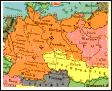
Lebach Area in Saarland
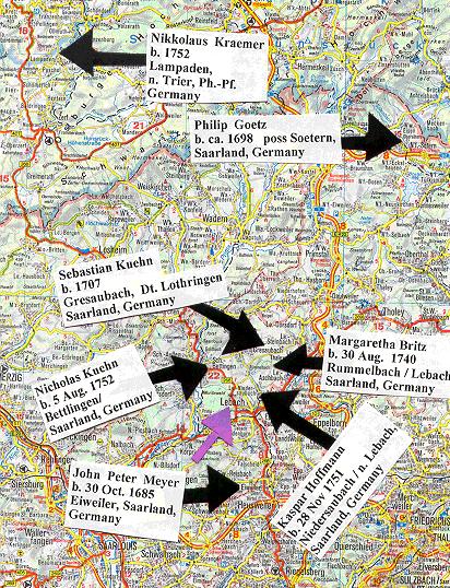
As one can see, many of the Hubert family ancestors migrated from the Saarland [Germany]. The ancestors marked on this particular map are connected to the families who migrated from the Lebach [see purple arrow] area of Saarland to Sackelhausen / Banat, Austria-Hungary. See map showing Lebach, Saarlouis and Saarbruecken.
These families are listed on my Sackelhausen Web Pages from "A" to "Zzzz".
The Hubert Family's migration is uncertain. There were Huberts listed as having migr. from Saarland and they are listed on the Trier Web Page. About 1748 their migration from Saarland or the Black Forest carried them to the village of Perjamosch.

These families are listed on my Perjamosch Web Pages from "A" to "Zzzz".
A List of Remmick and Hubert Families Migr. from to other parts of the world.
|
Perjamosch / n. Arad Banat, Austria-Hungary [Rumania] |
Hubert & Hummel Index Page |
Borodino Bess. History Home Site |
Remmick.Family.Tree |
List of All the Photographs on Remmick-Hubert Web Sites |