Last Updated: 10 July l 2012
![]()
![]()
![]()
UNDER CONSTRUCTION
BORODINO COLONIST ORIGINS CONTINUED
(2) PLACES IN POLAND & PRUSSIA
(3) PLACES IN MECKLENBURG& POMERNIA
![]() PLACES in
POLAND
PLACES in
POLAND![]() &
&
![]() PRUSSIA
PRUSSIA![]()
Page 2
A / B / C / D / E / F / G / H / I / J / K / L /
M / N / O / P / Q / R / S / T / U / V / W / X / Y / Z
Magrowolle (Wola Magierska) / by Warschau, Poland [Magierowa Wola / Warschau , Neuostpreussen, Poland] [Magierowa Wola / Gmina Warka Dist., Grojec County, Masovian Voivodeship, east-central Poland.
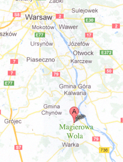 Map is from Google.
Address 05-660 Magierowa Wola, Poland.
Map is from Google.
Address 05-660 Magierowa Wola, Poland.
Location. About 7 km (5 miles) north of Warka and 23 km (14 milies) east of Grojec, and 43 km (27 milies) south of Warsaw. History.
![]()
Makraveic / ?? [See Magrowolle = Wola Magierska, Poland]
![]()
Margraviate of Brandenburg (Markgrafschaft Brandenburg = March of Brandenburg). It was a majory sovereign state of the holy Roman Empire (1157 - 1806). The ruler was the Electorate of Electoral Brandenburg (Kurbrandenburg). The House of Brandenburg and the minor house known as the House of von Hohenzollerns inherited the Duchy of Prussia which became Brandenburg-Prussia which became Kingdom "in" Prussia, then Kingdom of Prussia until it's defeat my Napoleon in 1806 but regained it's power after the deafeat of Napoleon in 1815 and became the Province of Brandenburg. In 1871 the uniification of the German states created the German Empire and the House of Hohenzollern held the crown of Emperor (Kaiser). After in WW I and the German defeat it became a Free State of Prussia.
![]()
A / B / C / D / E / F / G / H / I / J / K / L /
M / N / O / P / Q / R / S / T / U / V / W / X / Y / Z
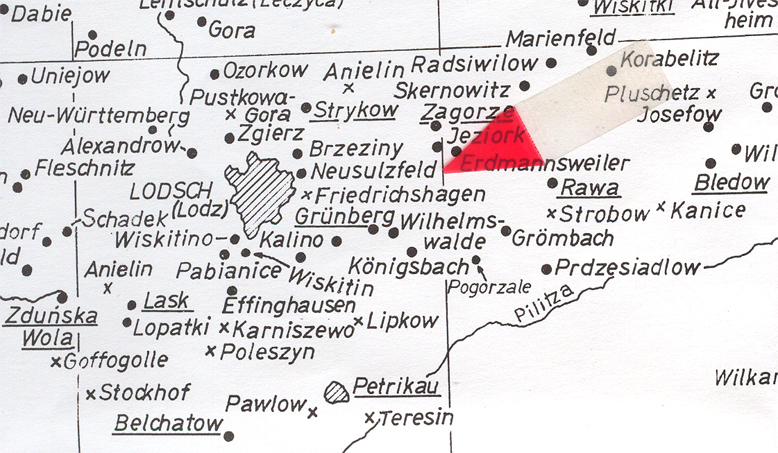
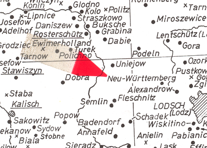
![]() Neu Sulzfeld (Neusulzfeld) / Lodz, Duchy of Warsaw
(Poland).
Neu Sulzfeld (Neusulzfeld) / Lodz, Duchy of Warsaw
(Poland).
MAP: From copyrighted material from GRHS . GRHC and AHSGR. Copied here in part with permission from all three organizations. All three have the complete map for sale in their stores.
Some colonists did not record themselves as migr. from Neu Sulzfeld but merely recorded Sulzfeld. Sulzfeld / Lodz, Poland: ( = Neu Sulzfeld / Lodz (Lodsch), Duchy of Warsaw (Poland) [Do no know the Polish name] According to Armin Zimmermann's web site (http://www.armin-zimmermann.eu/Bessarabien/Herkunft/Polen_englisch.html) and I quote, >>The settlers can be divided into two groups. The smaller group emigrated directly from Germany (e.g. Wuerttemberg, Baden, Bayern) and settled in Teplitz (1817), Sarata (1822), Gnadental (1830) and Lichtental (1834). The bigger group are the so-callled "Warschauer Kolonisten" (Warsaw colonists) from the grand duchy of Warsaw which was established by Napolein in 1807. They emigated 1814 and 1839 to Bessarabia. This migration is closely connected with the Polish and Prussian history and the partitions of Poland in 1772, 1776, 1793 and 1795.<< >> "Starting in 1800 the foundation of "Swabian villages" in South Prussa was performed mainly by the four domains, Laznow, Tcaczen, Zdiechow and Pabianice. Laznow to the east of Lodz attnded the foundation e.g. of Groembach (1800), Neu-Sulzfeld (1801), Wiaczyn (1804)_ and Gruenberg (1805). << See Lodz for history of area. Tsar Alexander I encouraged the Germans to head farther east to his newly acquired area of Bessarabia and many of the Germans did move. See history of German-Russians. Mr. Zimmermann has more details plus an excllent map showing German colonies in central Poland, so, do take a look and enjoy.
![]()
![]() New
East Prussia (Neuostprussen) 1795 to 1815: History: It was the
Province of the Kingdom of Prussia from 1795 to 1807 which was created with
the territory anncext from Poland in the Third Partition. This included
some of Masoovia and some of Podiaskie.
New
East Prussia (Neuostprussen) 1795 to 1815: History: It was the
Province of the Kingdom of Prussia from 1795 to 1807 which was created with
the territory anncext from Poland in the Third Partition. This included
some of Masoovia and some of Podiaskie.
Napoleon's victory in the War of the Fourth Coalition and the Great Poland Uprising of 1806 the New East Prussia was to be shared in 1807 due to the Treaties of Tilsit that were signed. The Plozk Dept., became part of the Duchy of Warsaw under the rule of the French. The Bialystok Dept. was taken by the Russian Empire.
![]()
Neuwuerttemberg (Neu-Wuerttemberg) / Lodz- (Lodsch), Poland
.
![]()
Northern March / North March (Nordmark). March merely refers to the "district" which was created in 965 out of lands conqured from the Wends, who were West Slavs, who became known as living within the Holy Roman Empire. The new ruler was Albert "the Bear" (House of Brandenburg), who inherited Brandenburg from the Hevelli ruler Pribislav.
![]()
A / B / C / D / E / F / G / H / I / J / K / L /
M / N / O / P / Q / R / S / T / U / V / W / X / Y / Z
![]() Oberwohschoen / Kulm, Prussia [?? ]
Oberwohschoen / Kulm, Prussia [?? ]
![]()
Old Prussia refers to Baltic tribes that inhabited the area were to know as Prussia. They retained the "old ways", the "old language Prussian" and were pagans. The people of the area were assimilated through the centures when the Teutonic Knighs ruled in the 13 th century and when the Germans controled the area that had consisted of southern East Prussia, area around Kaliningrad of Russia and the Klapieda Region of Lithuania. To the south the ripret Marshes and all the way to the headwater of the Dnieper River. And, let us not forget the influence of the Norseman who rowed up and down the rivers leaving their mark in the areas along the Baltic Sea and along the waterways of northern Europe..
![]()
![]() Ostpreussen. (See East Prussia)
Ostpreussen. (See East Prussia)
A / B / C / D / E / F / G / H / I / J / K / L /
M / N / O / P / Q / R / S / T / U / V / W / X / Y / Z
![]() Poland
Poland![]()
.
|
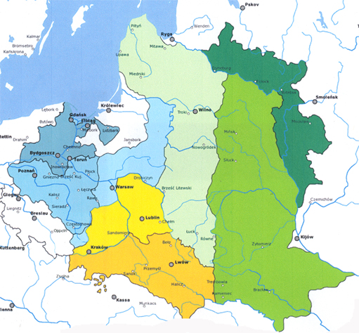
Partitions of Poland
|
|
Polish State uner Mieszko - 966
Kingdom of Poland 1025 to 1596
Grand Duchy of Poland 1596 1568
Grand Duchy of Lithuanian Commonwealth, (Union of ) The Kingdom of Poland and the Grand Duchy of Lithuania - 1596 to 1791
Parts of Poland became "Protectorate of the Russian Empire - 1768
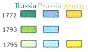
First Partition - 5 Aug 1772
Partion known as "May 3rd" - 3 May 1791
Commonwealth of Poland or "Serene Republic of Poland" - 1791
Second Partition - 23 Jan 1793
Third Partition of the Kingdom - 24 Oct. 1795 [Sections went to Kingdom of Prussia (New East Prussia) , Russian Empire and Austria]-
Duchy of Poland 1807 to 1815 (Occuppied by Napoleon 1806 to 1812; short war with Austria in 1809, then it was ocuppied by the Kingdom of Prussia 1812 to 1815. Parts were retaken by Russia in 1813. Prussian kept "Grand Duchy of Posen" and Russians kept the area known as the Duchy of Warsaw.)
"Congress Kingdom" of Poland 1815 to 1831
Annex to the Russian Empire in 1831
Duchy of Cracow 1846 to 1918 (Part of the Polish area became the official titulary of Austria, City of Cracow became a Free City. See Kingdom of Galicia and Lodomeria, Duchy of Auschwitz, & Duchy of Zator)
Second Polish Republic 1918
WW II -Invasion by the Germans
Invasion of the USSR to 1989 Revolution
Third Polish Republic - Present Time
----------
Example of a German, who was living in Poland, and gaining permission to migr. to Plotzk / Bess., S. Russia in the GRHS File6-1-4158a, Central Archive Directorte, Odessa Regional Historical Archive, Binding No. 1101, Reference No. 23879:
Johann Hein and family migr. to Plotzk / Bessarabia, S. Russia.
****************************************
Per the Decree
Of His Majest, Sovereign Emperor
NIKOLAUS PAVLOVICH
ALL-RUSSIAN AUTOCRAT.
[ETC. ETC. ETC.]
No. 3924
For the bearer, a resident of Plotzk District, Colonist Johann Hein, along with the people named on the other side.
Ont the basis of permiission from the Ruling Council of the Kingdom of Poland exit is permitted to go to the Province of Bessarabia for permanent residence there. While he is underway the Imperial military and civilian authorities within the Kingdom are obligated
and foreign authorites are invited to provide undhindered passage and in case of need are to provide the necessary aid.
This passport is provided uner my siignature and with my coat of arms stamp affixed.
In the city of Warsaw June 24/ July 6 1835.
Distingishing Characeristics:
Age: 26
Stature: medium
Eyes: brown
Hair: sandy
Beard: ___
Face: oblong
Nose: large
Special Caracteristics: __
Birth location: __
Redisence: ___
Under the Direction of the Warsaw Military Governor: ((signed) D----
Distingishing Characteristics of those traveling with Hein:
Christina wife, age 27, stature-medium, eyes-blue, hair-light brown, fact-oblong, nose-moderate
Elisabetha daughter, age 5, youngster
Andreas son, age 2, youngster
For the manager of the passport office - (sighed) Maber
No. 228 - probable border crossing endorsement (in Polish)
No. 920 - During the journey into Russia a registration at the reborovsk customs station on 13 Aug 1835. Magager - (signed) Suschinets
***********************************
//Note: This is most likely the Johann Hoehn family, Family No. 8 on the 1850 Plotzk census.
//NOTE: Page 542 Stumpp Bk.: Hoehn, Johann b. 1809 from Buchholz, Pr.
//NOTE: Plotzk was founded in 1839 with 39 families. So, where did Johann Hein/Hoehn live from 1835 to 1839?
--------------------------
LINKS TO HELP YOU FIND YOUR GERMAN VILLAGE NAME & PRESENT POLISH NAME:
![]()
![]() __??__ / __??__, Poland
__??__ / __??__, Poland
![]()
Posen / Posen Province, Poland
MAP: From copyrighted material from GRHS . GRHC and AHSGR. Copied here in part with permission from all three organizations. All three have the complete map for sale in their stores.
Posen, The Province Location. History It was created as art of the German Empire from 1874 to 1918. What had been known as "greter oland" in 1772 became Prussian known as the Netze Distic. In 1793 it became known as South Prussia. In 1807 during the Napoleonic Wars some of the territory became tthe Duncy of Warsaw. In 1815 the Congress of Vienna gave Prussia the western third of the Warsaw Duchy, which was about half of south Prussia Prussia gave the Psen area, known then as the Grand Duchy of Posen, a semi-automous position. The Posen (Poznan) Parliment voted against joining the German Confederition but the German's Frankfurt Parliament paid no attention to what the Poles in Posen wanted. Almost all the Polish people had been and would continue to be Roman Catholic. About 90 % of the German emingrants were Protestants with a smattering of Mennonites and the rest were Catholic. Jews were scattered across the area in groups. In the 1800s Poland was basically under a feudal system and ended in 1810. In the 1800s the German Settlement Commission bouth up land from the Polish people and made it available just to the Germans. Let me quote Wikipedia: >>An estate would have its manor an farm buildings, and a village nearby for the Polish laborers. Near that village, there might be a German settlement. And in the woods, there would be a forester's dwelling. The estate owners, usually of the nobiltiy, owned the local grist mill, and often other types of mills or perhaps a distillery. In many placed, windmills dotted the landscape, reminding one of the earliest settlers, the Dutch, who began the process of turning unproductive river marshes into fields. This process was finsihed by the German settlers who were used to reclaim unproductive lands (not only marshlands) for the host estate owners.<< Let me give you heads up on a fact. It is general thought that 25 % of the population in the Provice of Posen in 1815 was German (Catholics, Proestants and Jews). WW I and WW II occured which followed with the Red Army marching into the area. The USSR contoled the area under the title of Republic of Poland. See history of Poland for more details. List of German colonies around Posen from the Odessa Digital Library.
Poznan (=Posen), The City of Location. History Poznan is on the Warta River. It is said that it is the oldest city in Poland. Here in their cathedral most of the early Polish rulers were buried. The earliest document about the city was written in the chronicles of Thietmar of Mersburg which was written between 1012 and 1018. This document tells us that their was a Bishop of Poznan that eissted in 970. Therefore, the name was in latin and spelled "Posnania":. It is historically written that Mieszko I was baptised in Poznan in 966. Mieszko was of the House of Piast, the son of Sithe first Polish ruler eemomyskl, and, granson of Lestek..... After the death of Mieszko II's death, Bretislaus I of Bohemia destroyed both Poznan and Gniezno. After death of Boleslaw III (1138), Poland was divided as requested in Boleslaw III's will. In 1249 Duke Przemyysl built the Royal Castle on a hill on the left back of the Warta River. It is pesently art of Poznan.... The period that followed was continually divided ulntil 1320, After Poland became united, Poznan became the seat of a voivodeship, a unit in the government of Poland's adminstrative division of state and local governments. Poznan like the rest of Poland was under the Jagiellonian Dynasty who ended up ruing "Poland-Lithuania". On 2 May 1536 175 buildings including the castle was destroyed by fire.... In the 1600s, Poznan was affected by the Second and Third Northern wars, War of the Polish Succession, the Seven Years' War, Bar Confederation rebellion, and, to make things sorse, their wass outreaks of plague, and floods. The city that had held about 20,000 declined in population that was a about 6,000 about 1730. The ruler called Bambergians and Dutch settled into the devastated suburgs. But, any kind of success was hindered by the Second Partition of Poland.... Poznan came under the rule of Kingdom of Prussia (House of Hohenzollerns),wn as Prussia's Province of South Prussia. The city boundaries were expaned. The walled city and it's neighboring suburgs were incorpoarted in 1797 bollowed in 1800 by takeninghwaliszeewo, Srodka, Ostrowek and Lacina (St. Roch). The old city walls were torn down early in the 1800s and many of streets were changed. The Polish people were disatsfied and the Great Poland Uprising of 1806 occured and they supported Napoleon by driving out the Prussian troops. Poznan became part of the Ducy of Warsaw in 1807. It was the seat of the Poznan Department. But this was all changed when Napoleon was defeated and the Crongress of Vienna returned the area back to Prussia. Of THE Grand Duchy of Posen. The Great Poland Uprising during the Revolutions of 1848 proved to be fruitless for the Polish rebells. It remained part of the Prussian Empire and continued as the German states were unified in 1871. It wasn't until after WWI and the Greater Poland Uprising (1918-1919( that Poznana came ulnder the Poliish controle which was confirmed by the Treat of ersailes. Shee history of Poland for more details. WW II the German reentered Poznan. After the Germans were defeated, the Russians took contol, and the fall of communism occured in 1990. In 1999 Poznan became the seat of Poznana County in the country of Poland.
![]()
HISTORY OF BRANDNENBURG & PRUSSIA
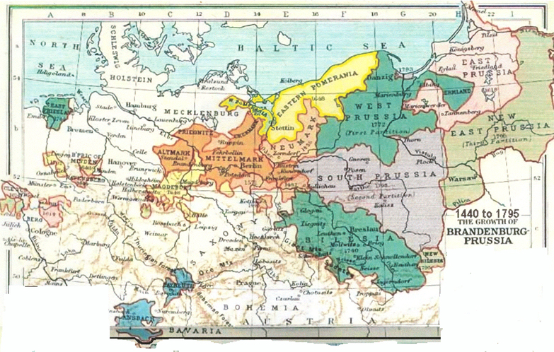

Map 1, 2 and 3 are not under copyright.
Prussia's Partitions of Poland in 1772, 1793 and
1795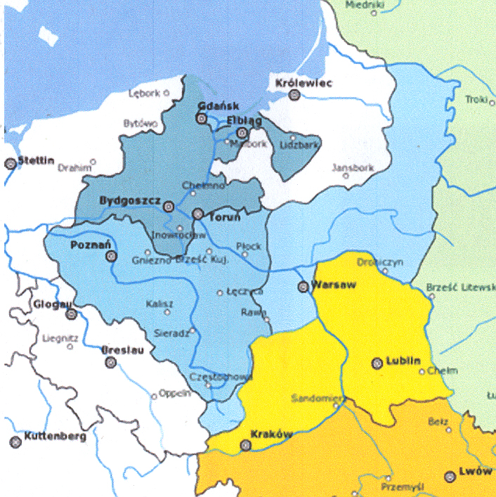
-----
![]()
__??__, Prussia
![]() __??__/__??__,
Prussia
__??__/__??__,
Prussia
A / B / C / D / E / F / G / H / I / J / K / L /
M / N / O / P / Q / R / S / T / U / V / W / X / Y / Z
![]()
A / B / C / D / E / F / G / H / I / J / K / L /
M / N / O / P / Q / R / S / T / U / V / W / X / Y / Z
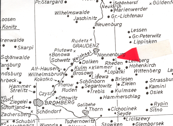
Rehden, Pr. [= Radzyn Chelminski/ Grudziadz (Graudenz) County, Kuyavian-Pomeranian Volvodeship, Poland] Location. History. This is , where the old medieval Ordensburg castle was built by the Livonian Brothers of the Sword and later additions were built by the Teutonic Knights during the Middle Ages when the area was a "monastic state" created to rule the pagan West-Baltic ("Old Prussia"). Afer the Battle of Grunwals in 1410 the Livonian Confederation was established (1422-1435) During the Reformation the state was renamed the Duchy of Prussia in 1525 when it came under the rule of the Protestants House of von Hohenzolleren. The German name was "Rehden" or "Reheden". A parsal of land that was to play a role in raising Frderick Wilhlem to a Duke in the Holy Roman Empire and he was in turn able to declare himself King "in" Prussia of he sovereign state Kingdom of Prussia in 1701. See Rudetz Prussia for more history on area. In 1806 Napoleon eliminated the Holy Roman Empire existence..... .
![]()
Royal Prussia (Prutenia / Ruthenia). History. It was created on 19 Oct 1466 and annexed on 5 Aug 1772. It was the conbmaltion of the Kingdom of Poland and the Polish-Lithuanian Commonwealth. (1569 -1772.) Is is not to be confused with Ducal Prussia. It was a vassel state (fief) under Polish rule until 1618 when it was inherited by the Electors of Brandenburg . Within the Royal Prussia were these important areas:
![]()
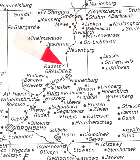
Rudetz / Graudenz, n. Kulm (Chelmno), Pr. ) [Rudetz (=??Graudziadz) / Kuyavian-Pomeranian, Poland] Location. Family members have visited the area and tell me that Rudetz never existed because there are no records. They suggest Rudetz / Rudez may actually be the city of Graudenz. In Karl Stumpp's records and his maps, Rudetz is shown just north of Graudenz. However it is marked with an "x" with the words "Lag ungenau", which means the position on the map is "not exact". In the Stumpp Bk. it is marked in another section as "Rudetz = Graudenz ??" History. Frederick "the Great" settled about 30,000 Germans in this eastern part of this eastern province, that had been part of Poland since 1440, afer the Prussian Partition of Poland in 1772.
![]() Schischest / __. Prussia [Schischest (??)], Prussia]
[ poss. Schidlitz / Danzig (Gdansk),
West Pussia; place name found in Stumpp Bk, however, it does not show on
his maps.]
Schischest / __. Prussia [Schischest (??)], Prussia]
[ poss. Schidlitz / Danzig (Gdansk),
West Pussia; place name found in Stumpp Bk, however, it does not show on
his maps.]
![]()
![]() Segartowitz
/ Kulm, Pr.
Segartowitz
/ Kulm, Pr.
![]()
![]() South
Prussia (Suedpressen): History. A province of the Kingdom of
Prussia from 1793 to 1807 that had been created out of the Ssecond Partition
of Poland.
South
Prussia (Suedpressen): History. A province of the Kingdom of
Prussia from 1793 to 1807 that had been created out of the Ssecond Partition
of Poland.
From 1793 to 1795 the capital was Poznan then from 1795 to 1806 the capital was Warsaw. In 1807 Napoleon's vistory in the War of the Fourth Coalition and Polish Uprising, the area of South Prussia (in part) became the Duchy of Warsaw, a French client state, after the Treaties of Tilsit in 1807. After the Congress of Vienna in 1815 it was was divided between the Prussian Grand Duchy of Posen, Congress Poland and part of the Russian Empire.
![]()
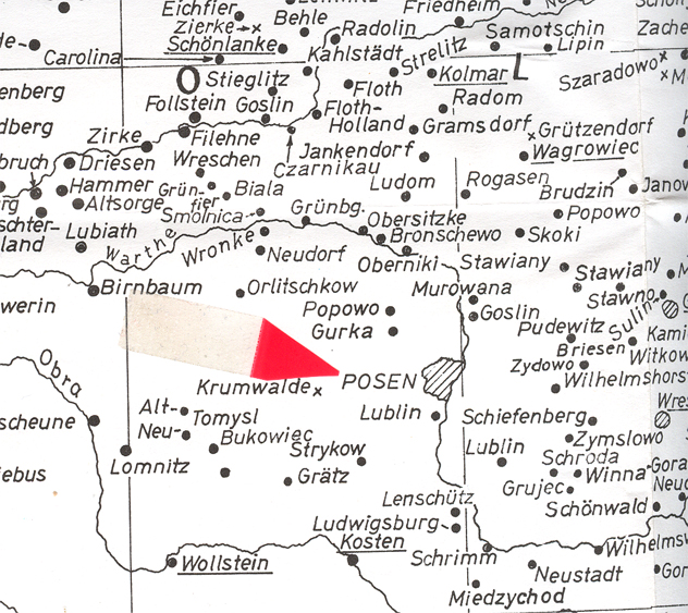
Sierakow (Zirke)-Po [Sierakow (Zirke), Gmina Dist, Miedzychod Country, Voivodeship is Greater Poland and it's in Poland] See Zirke, Prussia for more details plus map.
![]()
Schergowa (Zirke), ____, Poland
![]()
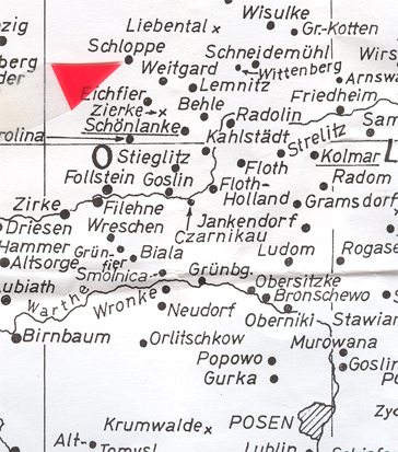
![]() Stadt Schloppe, Prussia [Schloppe = Czlopa / Walcz
County, West Pomeanian Voivodeship, Poland.]
Stadt Schloppe, Prussia [Schloppe = Czlopa / Walcz
County, West Pomeanian Voivodeship, Poland.]
MAP: From copyrighted material from GRHS . GRHC and AHSGR. Copied here in part with permission from all three organizations. All three have the complete map for sale in their stores.
Location. It is north of Zirke (Sierakow, Miedzchod Country, West Pomeranian Voivodeship] Poland) One of the maps tells us it is in the Koszalin region of Poland.History. Schloppe (the German name) is an ancienty city. It was built to protect the northern and wester broders. In the 1200s the Czarnkowski family was given possession of the region which includee Schloppe. Przemysl II, Prince of Greater Poland gave the permission to raise a "hill-fort". Looking up Koszalin (Koeslin) region we find the Chronicle of Greater Poland's history. In 1214 Bogislaw II, Duke of Pomerania asked Germans to settle his territory that was called "Kolobrzeg Land".In 1534 during the Protestant Reformation, Coseslin became Evangelical Lutheran. Their leader was Johannes Bugenhagen. After the Thirty Years' War, the city of Coeslin was grandted to Brandenburg-Prussia. After the Treaty of Westphalia in 1648 and the Treaty of SAtett in 1653 Farther Pomerania became a part of Brandenburgian Pomerania. 1807 The Frency troops were in the area. Aftr the defeat of Napoleon, Coeslin became capital of the Fuerstenthum Distry in the Regierungsbezirk Coeslin revion in the Provice of Pomerania.
![]()
![]() Stufen / Thorn, Prussia [Stufen (??)]
Location. I coud not find
a Stuffen near Thorn (Torun), Poland on the old map. History. Take a
look at the Thorn section which has a map. .
Stufen / Thorn, Prussia [Stufen (??)]
Location. I coud not find
a Stuffen near Thorn (Torun), Poland on the old map. History. Take a
look at the Thorn section which has a map. .
![]()
![]() Suedpressen
(See South Prussia)
Suedpressen
(See South Prussia)
![]()
![]() Sulzfeld / Lodz, Poland:
See
Neu Sulzfeld / Lodz (Lodsch), Duchy of Warsaw (Poland)
Sulzfeld / Lodz, Poland:
See
Neu Sulzfeld / Lodz (Lodsch), Duchy of Warsaw (Poland)
![]()
A / B / C / D / E / F / G / H / I / J / K / L /
M / N / O / P / Q / R / S / T / U / V / W / X / Y / Z
Thorn, Prussia [Thorn = Torun/ Torun County, Kuyavian-Pomeranian Voivodeship, Poland.]
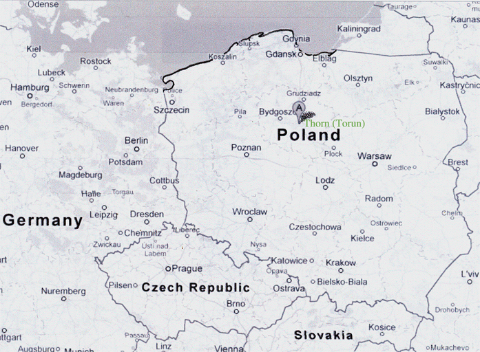 Google Map on Torun,
Poland - 2012
Google Map on Torun,
Poland - 2012
Location. See "A" on map above. History. Archaeologist date villages in this area which reaches into what is known today as part of Poland, arts of Czech Republic and Slovakia as well as eastern Germany and the Ukraine. go back to 1100 BC and call it the Lusatian culture, which existed in the later part of the Bronze Age and early Iron Age. The Slavic settlement was at a ford in the Vistula River which later was known as Torun to the Slavs and Thorn to the Germans. In 1230 the construction of the Teutonic Knights castle was built upon the Slavic ground and the charter for Torn, Kulm (Chelmno) was signed in 1244 and it became a part of the Kulm lay. Franciscan monks arrived in 1263 and then by the Dominicans monks in 1239. New Town was established in 1264 and joined the Hanseatic League in 1280 making it an important medieval center for trade. The First Peach of Thorn was singed at the end of the Polish-Lithuanian-Teutonic War in the mont of Feb. in 1411. The Prussian Confederation was governed by the land of gentry in 1440 and 14 years later rose up against the Monastic state of the Teutonic Knights which was called the Thirteen Years" War. The Polish, are so it's claimed, destroyed the Teutonic castle. At the end of the Thirteen Years' War in 1466 the Second Peace of Thorn was signed and the Tuetontic Order lost control of the western provinces and became part of Royal Prussia. Thorn was a art of the Kingdom of Poland. Peace lasted until the Protestant Reformation. In 1557 Thorn adopted Protestantism while most of the other Polish cities remained Roman Catholic. Although the Protestants tried to keep the Roman Catholics away, they continued to return after the arrival of the Jesuits in 1595 who were followed by the Dominican monks. The Protestants ended up with one church, St. Mary's...... Tensions between Catholics and Protestants were never very good to this point in time. The Great Northern War occurred from 1700 to 1721 and Augustus the Strong, King of Poland, who had been Protestant converted to Catholicism and pledged allegiance to the Habsburgs of Austria, who were Catholic, gained control. As King of Poland, he was not successful. 50 % of the populace became German and they created a protest... The mayor and 9 other Lutheran officials were blamed, sentenced to death, and executed on 7 Dec 1724 and this event was to be called the Tumult of Thorn. In 1793 the Protestant Kingdon of Prussia annexed Thorn after the Second Partition of Poland. The French under Napoleon marched into Thorn and the city and the area became part of the Duchy of Warsaw, but, Napoleon was defeated by 1814 and the Prussians regained Thorn. During the Franco-Prussian War (19 July 1870 to 10 May 1871), the Prussians made their French prisoners build a chain of forts around Thorn. Prussia became a part of the Hohenzollerns new German Empire. In 1919, after WW I, Torun was assigned to Poland and it became the capital of the Pomeranian Voivodeship. In 1939 the Nazi annexed Thorn after they invaded Poland and Thorn became part of the Danzing- Prussia. After WW II, it became part of Poland.
The various names for Torun were: Thorun, Turon, Turun, Toron, Thoron and Thorn. More than likely, the name dervied from the castle built by the Tuetonic Knights who named it after Toron (Tibnin) which had sifnificant meaning in the history of the crusades for it was a castle built on the road from Tyre to Damascus. If you have time, take a look at the history of "Toron" in southern Lebanon.
![]()
![]() Trebis, Prussia. [Trebis / n. Kulm , West Prussia ]
Trebis, Prussia. [Trebis / n. Kulm , West Prussia ]
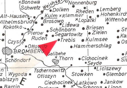
MAP: From copyrighted material from GRHS . GRHC and AHSGR. Copied here in part with permission from all three organizations. All three have the complete map for sale in their stores.
Location. History. See Kulm (Chelmno), Poland for history of the area.
![]()
A / B / C / D / E / F / G / H / I / J / K / L /
M / N / O / P / Q / R / S / T / U / V / W / X / Y / Z
![]() Unislaw / Kulm, West Prussia [Unislaw / Gmina Krotoszyn
Dist., Krotoszyn County, Great Poland Voivdesip., Poland.
Location. It is just
south of Chelmno (Kulm) abt 18 km (11 milies) and not shown on the
old map I've been using. Google map has it as "Gmina Unislaw").
History. See Kulm for history of the
area.
Unislaw / Kulm, West Prussia [Unislaw / Gmina Krotoszyn
Dist., Krotoszyn County, Great Poland Voivdesip., Poland.
Location. It is just
south of Chelmno (Kulm) abt 18 km (11 milies) and not shown on the
old map I've been using. Google map has it as "Gmina Unislaw").
History. See Kulm for history of the
area.
![]()
A / B / C / D / E / F / G / H / I / J / K / L /
M / N / O / P / Q / R / S / T / U / V / W / X / Y / Z
Warschau, City of, Poland Location. It is on the Vistula River, which carries it's important waterway to the Gdansk Bay and the Baltic Sea. History. The first doumented city of this area was called Brodno abt 800. It took up a different name in the 1100s and it was called Jazdow. Nearby was a small fishing village known as Warszowa. About 1300 prince Boleslaw II of Masovia took notice of Warszowa and thereafter it has been called Warsaw. The Warsaw Confederation estabished religious freedom in the Polish-Lithuanian Commonwealth. Warsaw became the Commonwealth's capital. King Sigismund III (House of Vasa) moved his court from Krakow to Warsaw in 1596. The city was sieged three times by the Swedish, Brandenburian and Translvanian forces between 1655 to 1658. By 1700 the Great Northern War, a coflict between Russia and Sweden, heavily touched Warsaw who was told they had to contribute. The last king of the Commonwealth was Stanislaw Augus Poniatowoski (Stanslaw II August) when he abdicated and was considered a captive of Russia and lived out his days in St. Petersburg as a "semi-captive". Warsaw was annexed by Prussia in 1795. Napoleon changed the political scene in 1806 and Warsaw was made the capital of thew Duchy of Warsaw. After Napoleon's defeat and following the Congress of Vienna of 1815, Warsaw was to be the center of the new Congress Poland (Russia's Poland). The Polish struggled against the Russian hold. Nazi troops occupired Warsaw in 4 Aug 1915 to 1918. From this point to modern times, a great deal occured between the Russians and the Germans. WSasaw is presently part of Poland which came into it's own and is striving for democratic changes since 1979. The collapse of the communist regime took placed in 1990 through it's "solidarity movement".
![]()
![]() Wenerotzlaff (??) / _____, Prussia and Wenterotslaff
(??), __ Prussia
Wenerotzlaff (??) / _____, Prussia and Wenterotslaff
(??), __ Prussia
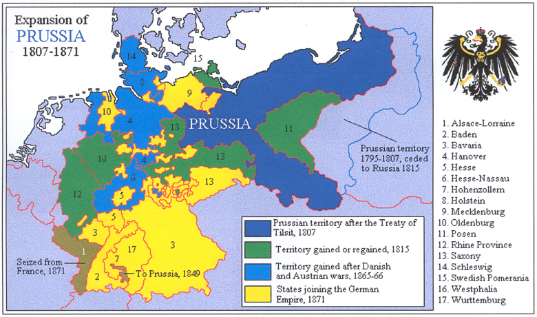
![]() West
Prussia (Westpressen) History: The area known West Prussia was created
twice. First time was 1773 to 1824. The second time was in 1878
to 1919/20. Today, most of West Prussia is part of Poland's Pomeranian
Volvodeship, It's capital is Danzig
West
Prussia (Westpressen) History: The area known West Prussia was created
twice. First time was 1773 to 1824. The second time was in 1878
to 1919/20. Today, most of West Prussia is part of Poland's Pomeranian
Volvodeship, It's capital is Danzig
Frederich II "the Great" invited Germans to immigrant to West Prussia. About 300,000 settled in the areas gained from the First and Second Partition of Poland. According to historicans, the Germans were favored over the Poles which lead to resentment. For example: (1) Govrnment contracts were won by the Germans; (2) Germans received the best location in cities and towns; (3) Soldiers were told not to shop in stores owned by Poles; and, then (4) there was the "tax incentives" which the German were entitled.
![]()
A / B / C / D / E / F / G / H / I / J / K / L /
M / N / O / P / Q / R / S / T / U / V / W / X / Y / Z
![]()
A / B / C / D / E / F / G / H / I / J / K / L /
M / N / O / P / Q / R / S / T / U / V / W / X / Y / Z
Zirke = Sierakow (Zirke)-Po [Sierakow (Zirke), Gmina Dist, Miedzychod Country, Voivodeship is Greater Poland and it's in Poland]
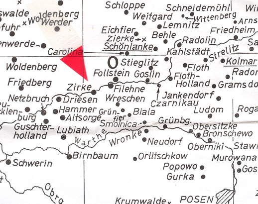
MAP: From copyrighted material from GRHS . GRHC and AHSGR. Copied here in part with permission from all three organizations. All three have the complete map for sale in their stores.
Location. It is near the Warta River. History. It has been in the Greater oland Voivodeship since 1999 and had reviously been in the Pozan Voivodeship from 1975 to 1998. Wikipedia's article doesn't give earlier information. There is a Sierakow Castle. The local church has the sarcophagus or the Opalinski family. Click on the link and the offical site, which is in Polish, and English will rovide you wtih photos, map, etc. (http://www.sierakov.pl/) Also found as Gmina Sierakow.
![]()
![]()
A / B / C / D / E / F / G / H / I / J / K / L /
M / N / O / P / Q / R / S / T / U / V / W / X / Y / Z
(2) PLACES IN POLAND & PRUSSIA
(3) PLACES IN MECKLENBURG & POMERANIA


Borodino.Bess.Genealogy
|
Hein Genealogy |
|
Borodino/Bess.Site |
Hubert |
Schweikert Genealogy |