Hohenzollern Photograph Index: Genealogy, Remmick-Hubert Home Site
Last Updated: 29 Sept 2003
![]()
![]()
![]()
Hohenzollerns continued......
for
Burg Hohenzollern [Fortress/Castle] Pages
&
Grounds Map
near Hechingen / Tuebingen, Baden-Wuerttemberg, Germany

Click On This Symbol And You Will Return Here
Hohenzollern, Burg [Castle/ Fortress] Potographs, A List of:
Map of the Grounds of the Hohenzollern Fortress and Castle Area - 1991
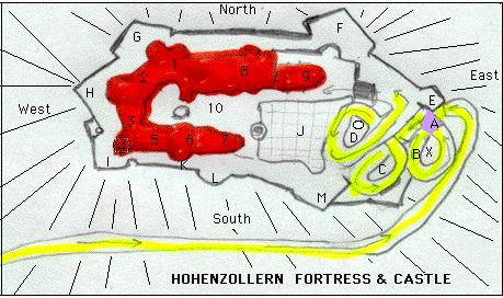
LOWER PART OF THE FORTRESS
A. = Alter Thor = Old [Watch] Tower through which a person passses through twice on two different levels
B.= Takes about a half hour to walk up the roadway to the walkway at the top of the fortress wall
X = Wilhelms Thurn= Williams [Watch] Tower
C. = Niederes Vorwerk = Part of the Lower Fort
D. = Rampenthurn mit gewoebter u darueber undbechter Arlfahrt
SENRIES' BASTIONS
[Walkway on top of the Walls of Fortress]
E. = Schnarrwacht - Bastrei = Sentrie's Bastion
F.= Neue Bastel = New Bastion
G. = Fuchsloch-Bastei = Foxhole Bastion
H. = der Spitz u. Bischofshurn = The Point
I. = Scharfeck - Bastrei u.. Markgrafenthurn = Corner Bastion
J. = Terrace [Castle] Garden
K. = Michaels-Thurn = Michael's [Watch] Tower
L. = Garten-Bastei = Garden's Bastion
M. = Michaels-Bastei = St. Michael's Church Bastion with Crown Prince Graveyard
BUILDINGS
1. Schuofa = Ancestral Hall
2. Count's Hall
3. Library
4. Margrave's Room
5. Picture Cabinets
6. Queen's Room (Blue Drawing Room)
7. Katholische Capelle = Catholic Chapel = St. Michael Chapel
8. Evangelische Capelle = Envangel Lutheran Chapel [Christ Chapel]
9. Wehrhaus = Restaurant
10. Coutyard
This Will Return You To Hohenzollern Index Page