Last Updated 22 April 2003
![]()
![]()
![]()
Schweikert Family continued....
Where Is Katherinfeld and Other German-Russian Villages In South Caucasus?
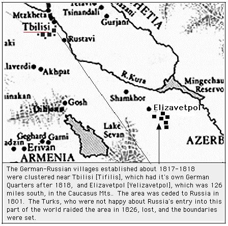
List of German-Russian Villages By 1818-1823
Alexander (ev)
*Annemfeld (ev)
Elisabethtal (ev)
Katharinfeld (ev)
German Quaters] in Tifilis (ev)
Gnadenburg (ev)
*Helenendorf (ev)
Kidoste (ev)
Marienfeld (ev)
Neu-Tifilis (ev)
Petersdorf (ev)
Reni (ev)
*The villages found near Elizavetpol
** Elizavetpol was called Ganzha before 1804 by the Turks who had built the mosque of Shah Abbas and planted the huge "Plane-trees" which Baedecker describes in his travel book p. 475. Later, it was known as Kirovabad. Baedecker also talks about the German colony of Henendorf which he stated was 8 miles south. This area is on the line that separates the South Caucasus with the Transcausian Steppe. The streams and rivers flow toward the Caspian Sea. By 1912 the population was 60,000.
***Tifilis gained its name from the sulpur springs was known as Tbilis or Tbilizi Kalaki. The Georgian Tzar Vakhtang Gurganzlan, who lived from 446 to 499 AD, was said to have discovered this area while hunting. In the early part of the 6th century it replaced Mtzkhet as the capital of the Kingdom of Georgia. The Tartar Timur in 1395 invaded the town and became part of the suzerainty of Persia. From time to time the Turks raided. In 1795 the Persians destroyed the town and in 1801 it was ceded to Russia. From that time forward the Russians kept the headquarters of the 1st and 2nd Caucasian Army Corps. One of the more famous soldiers who was stationed here was Leo Tolstoy. In the town is the steep banks of the Kura River and in one location there is a 60 foot falls where it channels into a narrow gorge before rushing off toward the Caspian Sea to the east. It is a town located on a trade route between the Casptian Sea to the Black Sea. The important merchanise was various gods, shoes, wine and tobacco. The factories produced carpets, ietmes of wool and cotton. The population by 1912 was 350,000 and mainily Georgians, Armenians and Russians. Althought quite hot in the summer, the winters are mild and about 74 degrees. Autumn is the most pleasant.
Here is what else Baedecker tells us: "The streets are generally stepp and often so narrow that two carriages cannot pass each others. The houses, mostely adorned with balconies, are perched on above the other on the mountain slop, like the steps of a staircase....the population include the Georgian dealers in vegetables, fuits and fish with their large wooden trays on their heads; the Persians, in their long caftans and their high black fur caps, often with red dyed hair and finger-nails; the tarters seids and mulahs, inflowing raiment with green and white turbans; the smoth-shaven Tartars in ragged clothing; the representatives of various mountrain tribes in their pictueresque tscherkeska and shaggy fur caps; and women never appar in the street without their veils. Among ohter features are the lively little donkets bearing heavy loads or idden by one of more men, and the horses carying waterskins, with their gaily-clad attendants."
"...about 12 miles SW...Kodzhori [mountain that rises 4,350 feet) are the ruins of several old Georgian chruches....About 7 miles to the south is the German colony of Elisabethtal ..."
"....About 1 1/4 milie to the N. is the German colony of Alexzndersdorf...."
See Map #2 showing the general area of the Caucasus.
See Map #3 of Black Sea which shows the areas around it
and
|
Remmick Home Site |
Borodino Home Site
|
Schweikert Genealogy
|